
Two kinds of coast
Coastal vineyards do not all meet the same sea. On the west side of the continents, the great currents of the subtropical oceans flow towards the equator and are cold; the Humboldt, California, Benguela and Canary systems are of this kind. Elsewhere a current can carry warm water towards the pole: the Leeuwin Current off Western Australia and the North Atlantic Current towards north-west Europe.
The chain this article follows is the same in every case. Sea temperature changes air temperature; air temperature, together with cloud and fog, changes how much heat the vines collect and how the ripening season runs. What differs is the sign: cold water cools the summer air and brings fog, while warm water mainly softens the winter.
Each statement is tied to a source listed at the end of the page. Where a figure, such as a vineyard temperature, could not be confirmed in a primary source, the article gives no number and says so.
Upwelling: why the sea off a west coast is cold
NOAA describes upwelling along eastern ocean boundaries as follows. Wind blowing towards the equator along the coast, together with the Earth’s rotation, drives an Ekman transport of surface water about 90 degrees from the wind direction, away from the shore. The surface water is then replaced from below by colder, nutrient-rich water.
NOAA Fisheries gives numbers for the northern part of the California Current: the wind moves the upper 15 m of water offshore, and it is replaced by cold water of about 8 °C that comes from 100–125 m depth near the shelf break. In that part of the system, strong northerly winds that blow from April to September drive upwelling along the Oregon and Washington coasts. The California Current itself is a cool flow southward from British Columbia to Baja California, and upwelling is its dominant physical driver.
The Humboldt system works in the same way off Chile and Peru. Thiel and colleagues place it from about 42°S northward and describe a northward flow of sub-Antarctic surface water plus strong upwelling of cool subsurface water. Off northern Chile the upwelling is nearly continuous; off south-central Chile it is more seasonal, in spring and summer.
From cold water to fog and sea breeze
Cold water cools the air above it from below. NOAA explains that the air temperature then rises with height, which is a temperature inversion; the cool, moist air beneath it is the marine layer, and where the air is cooled below its dew point, fog or low cloud forms. The National Weather Service calls this advection fog: moist air moving over a colder surface such as cold water. Unlike the radiation fog of calm, clear nights, it can form with cloud and with moderate to strong wind. On west coasts, NOAA notes, a marine layer can persist for days or weeks.
The sea breeze carries cool air inland. Sunlight heats only the top of the soil but penetrates deep into water, so land warms faster than the sea. The warmer air over land becomes less dense and forms a weak low pressure, and cooler, denser marine air flows in beneath it (NOAA JetStream). NOAA also notes that cooled marine air can spill over coastal mountains into inland valleys. Because the breeze is driven by the heating of the land, its cooling arrives in the afternoon, when the land is warmest.
The figure puts both processes in one cross-section: upwelling on the left, the marine layer and the sea breeze on the right. Apart from the NOAA figures quoted in the callouts, heights, distances and temperatures are not to scale.
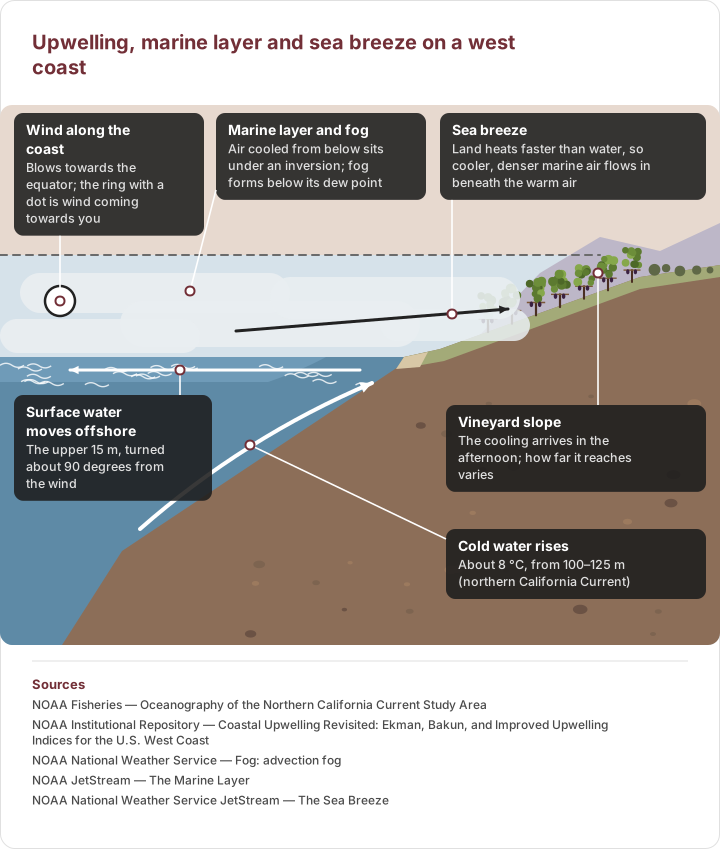
Diagram drawn from sourced data
A cross-section of a west coast. Left: wind along the coast moves the surface water offshore and cold deep water rises. Right: the cooled air forms a marine layer under an inversion, and the sea breeze carries it inland over vines. The view looks north along a Northern Hemisphere coast, so the ring with a dot marks wind blowing towards the viewer. Shapes and distances are illustrative.
- Wind along the coast — Blows towards the equator; the ring with a dot is wind coming towards you
- Marine layer and fog — Air cooled from below sits under an inversion; fog forms below its dew point
- Sea breeze — Land heats faster than water, so cooler, denser marine air flows in beneath the warm air
- Vineyard slope — The cooling arrives in the afternoon; how far it reaches varies
- Surface water moves offshore — The upper 15 m, turned about 90 degrees from the wind
- Cold water rises — About 8 °C, from 100–125 m (northern California Current)
Sources
- NOAA Fisheries — Oceanography of the Northern California Current Study Area
- NOAA Institutional Repository — Coastal Upwelling Revisited: Ekman, Bakun, and Improved Upwelling Indices for the U.S. West Coast
- NOAA National Weather Service — Fog: advection fog
- NOAA JetStream — The Marine Layer
- NOAA National Weather Service JetStream — The Sea Breeze
Humboldt and California: Chile and the Sonoma Coast
Chile. Vineyards are separated from the Pacific by the Coastal Cordillera. Wines of Chile says that in the Colchagua Valley the low elevation of the coastal hills lets Pacific breezes interact with winds from the Andes, which cools the valley and extends the ripening period. The article on the Humboldt Current and Chile’s Coastal Range follows that chain from cold sea to marine layer to valley. This article gives no temperature figures for Casablanca, Leyda or San Antonio: the figures repeated in trade media could not be confirmed in a primary source.
California. The cool California Current, and the upwelling that NOAA names as its dominant driver, are the source of the marine layer that NOAA describes for California’s coast. The West Sonoma Coast AVA, established by the Alcohol and Tobacco Tax and Trade Bureau (TTB) in 2022 and lying inside the Sonoma Coast and North Coast AVAs, is one of the coastal appellations facing this sea. How far the fog reaches into each appellation is described in the petition texts, which could not be opened for this article, so no fog-line, degree-day or distance figure is given. The appellations of Santa Barbara County are left out for the same reason. How the same fog reaches the Napa Valley is covered in the article on Napa’s valley floor and mountains.
Benguela and Canary: South Africa and Portugal
South Africa. The Benguela Current Convention describes the Benguela system, shared by Angola, Namibia and South Africa, as one of the four major eastern boundary upwelling systems, bounded by the warm Angola Current to the north and the Agulhas Current to the south. FAO describes cold, seasonal, wind-driven upwelling off the south and west coasts of southern Africa. In the Wine of Origin list published by SAWIS in October 2023, Elgin and Walker Bay are districts of the Cape South Coast region and Swartland is a district of the Coastal Region. Wines of Elgin credits summer south-easterly sea breezes off the cold Atlantic, and the cloud they bring, for part of Elgin’s climate, but it also points to the valley’s elevation of about 250–500 m: the current is one cause among several, and the article on Elgin keeps them apart. No cooling figure is given for Walker Bay or Swartland, because the numbers in circulation could not be confirmed.
Portugal and north-west Spain. A review of the Canary/Iberia upwelling system places Portugal and north-west Spain at its northern end. Along-shore northerly winds, blowing from about April to September, drive Ekman transport away from the coast and upwelling, and the strength varies from year to year with the North Atlantic Oscillation. The Vinho Verde commission (CVRVV) describes a region demarcated in 1908, an amphitheatre rising from the Atlantic coast, where east–west river valleys let maritime winds penetrate; it lists moderate temperatures, high rainfall, granitic soils and nine sub-regions. The commission describes an Atlantic influence; it does not attribute it to upwelling, and neither does this article, because the sources used do not measure that link.
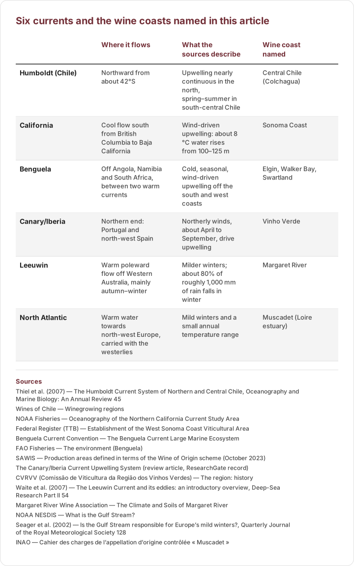
Diagram drawn from sourced data
What the cited sources say about each current, and the coast it is linked to here. The table describes the sea; it does not rank the wines.
| Where it flows | What the sources describe | Wine coast named | |
|---|---|---|---|
| Humboldt (Chile) | Northward from about 42°S | Upwelling nearly continuous in the north, spring–summer in south-central Chile | Central Chile (Colchagua) |
| California | Cool flow south from British Columbia to Baja California | Wind-driven upwelling: about 8 °C water rises from 100–125 m | Sonoma Coast |
| Benguela | Off Angola, Namibia and South Africa, between two warm currents | Cold, seasonal, wind-driven upwelling off the south and west coasts | Elgin, Walker Bay, Swartland |
| Canary/Iberia | Northern end: Portugal and north-west Spain | Northerly winds, about April to September, drive upwelling | Vinho Verde |
| Leeuwin | Warm poleward flow off Western Australia, mainly autumn–winter | Milder winters; about 80% of roughly 1,000 mm of rain falls in winter | Margaret River |
| North Atlantic | Warm water towards north-west Europe, carried with the westerlies | Mild winters and a small annual temperature range | Muscadet (Loire estuary) |
Sources
- Thiel et al. (2007) — The Humboldt Current System of Northern and Central Chile, Oceanography and Marine Biology: An Annual Review 45
- Wines of Chile — Winegrowing regions
- NOAA Fisheries — Oceanography of the Northern California Current Study Area
- Federal Register (TTB) — Establishment of the West Sonoma Coast Viticultural Area
- Benguela Current Convention — The Benguela Current Large Marine Ecosystem
- FAO Fisheries — The environment (Benguela)
- SAWIS — Production areas defined in terms of the Wine of Origin scheme (October 2023)
- The Canary/Iberia Current Upwelling System (review article, ResearchGate record)
- CVRVV (Comissão de Viticultura da Região dos Vinhos Verdes) — The region: history
- Waite et al. (2007) — The Leeuwin Current and its eddies: an introductory overview, Deep-Sea Research Part II 54
- Margaret River Wine Association — The Climate and Soils of Margaret River
- NOAA NESDIS — What is the Gulf Stream?
- Seager et al. (2002) — Is the Gulf Stream responsible for Europe’s mild winters?, Quarterly Journal of the Royal Meteorological Society 128
- INAO — Cahier des charges de l’appellation d’origine contrôlée « Muscadet »
Warm currents: Margaret River and north-west Europe
Margaret River. Waite and colleagues describe the Leeuwin Current as an anomalous poleward eastern-boundary current: warm, low-salinity water flows south along Western Australia, round Cape Leeuwin and east towards the Great Australian Bight, mainly in autumn and winter and against the prevailing winds. CSIRO explains that Pacific trade winds pile warm water up in the western Pacific, and the resulting sea-level difference drives it through the Indonesian passages and south along the Western Australian coast. The Margaret River Wine Association describes a maritime Mediterranean climate with about 80% of roughly 1,000 mm of annual rain falling in winter, and a Leeuwin Current that softens the climate and, through evaporation, contributes to the winter rain. The association also credits the current with cooling in summer. Because the current flows mainly in autumn and winter, this article reads its effect as winter mildness and does not credit it with summer cooling.
North Atlantic. NOAA says the Gulf Stream carries warm tropical water to north-west Europe. But Seager and colleagues (2002) asked whether the Gulf Stream is responsible for Europe’s mild winters and found the answer less clear-cut than the popular claim: the westerly winds that carry heat stored in the ocean are an essential part of it. The text therefore speaks of the warm North Atlantic and the westerlies, not of the Gulf Stream alone. The INAO specification for Muscadet describes an oceanic climate with a small annual temperature range because of the nearby ocean, the Loire estuary and Lake Grand-Lieu. Bordeaux and Galicia lie on the same sea, but climate figures for them could not be confirmed, so none are given.
Exercise 1: from wind to fog to vine
[Question]
Explain how a cold current can lower the temperature of a vineyard a few kilometres inland on a summer afternoon.
[Model answer]
Wind blowing towards the equator along the coast, together with the Earth’s rotation, moves surface water offshore at about 90 degrees to the wind, and colder deep water rises to replace it; in the northern California Current NOAA gives about 8 °C water from 100–125 m. Air cooled from below forms an inversion with a cool, moist marine layer under it, and where the air is cooled below its dew point, advection fog forms. In the afternoon the land heats faster than the sea, a weak low forms over it, and denser marine air flows inland as a sea breeze, through valleys and over low hills, so the vines receive cooler air.
[Mark scheme (6 marks)]
• Links wind along the coast and the Earth’s rotation to offshore transport and rising cold water (2 marks)
• Explains the cooled air, the inversion, the marine layer and advection fog (2 marks)
• Explains the sea breeze as a result of land heating, carrying marine air inland in the afternoon (2 marks)
Exercise 2: reading a warm-current or cold-current claim
[Question]
One brochure says “the Gulf Stream warms our vineyards”; another says “the Leeuwin Current cools our summers”. Using the sources of this article, say how each claim should be judged.
[Model answer]
The Gulf Stream claim is incomplete. Seager and colleagues (2002) found the answer less clear-cut than the popular claim, and the westerly winds that carry ocean-stored heat are essential to it; a careful claim speaks of the warm North Atlantic and the westerlies and of mild winters with a small annual range, as in the Muscadet specification. The Leeuwin Current is a warm poleward flow, mainly in autumn and winter, and its documented effects are winter mildness and winter rain; the summer cooling is the association’s own description and is not shown by the sources used, so a summer-cooling claim needs its own evidence, such as the site’s own measurements. Both claims should be treated as statements to check, not as facts.
[Mark scheme (6 marks)]
• Says the Gulf Stream is not the sole cause and names the westerlies (2 marks)
• Places the Leeuwin Current’s flow in autumn and winter and its effect in winter mildness and rain (2 marks)
• Separates winter effects from summer effects and treats both claims as things to verify (2 marks)
Sea
- Wind along the coast and the Earth’s rotation move surface water offshore
- Cold deep water rises to replace it
- A warm current mainly softens the winter instead
Air
- Air is cooled from below and an inversion forms
- A marine layer and advection fog form
- The sea breeze carries cool air inland in the afternoon
Vine
- Afternoon heat is moderated
- How far it reaches depends on valleys, hills and elevation
- To be checked with each site’s own data
Frequently asked questions
What is upwelling and why does it matter for wine regions?
Upwelling is the rise of cold, nutrient-rich deep water to the surface when wind and the Earth’s rotation push surface water away from a coast. Along west coasts it keeps the sea cold, and NOAA gives about 8 °C water from 100–125 m for the northern California Current. The cold sea cools the air above it and can produce fog, which is why coastal vineyards there can be cooler than sites further inland.
Does the Gulf Stream make Europe’s winters mild?
Not on its own. NOAA says the Gulf Stream carries warm tropical water to north-west Europe, but Seager and colleagues (2002) found the answer less clear-cut than the popular claim: the westerly winds that carry heat stored in the ocean are an essential part of the explanation.
Does a cold current cool every vineyard near the coast?
No. The cooling depends on the wind, on whether valleys or low hills let marine air in, and on other factors such as elevation. Wines of Chile ties Colchagua’s cooling to low coastal hills, and Wines of Elgin points to elevation as well as sea breezes and cloud.
Sources
- NOAA National Weather Service JetStream — The Sea Breeze
- NOAA National Weather Service — Fog: advection fog
- NOAA JetStream — The Marine Layer
- NOAA Institutional Repository — Coastal Upwelling Revisited: Ekman, Bakun, and Improved Upwelling Indices for the U.S. West Coast
- NOAA Fisheries — Oceanography of the Northern California Current Study Area
- Thiel et al. (2007) — The Humboldt Current System of Northern and Central Chile, Oceanography and Marine Biology: An Annual Review 45
- Benguela Current Convention — The Benguela Current Large Marine Ecosystem
- FAO Fisheries — The environment (Benguela)
- Waite et al. (2007) — The Leeuwin Current and its eddies: an introductory overview, Deep-Sea Research Part II 54
- CSIRO — The good-news El Niño story for Western Australia’s oceans (2015)
- Margaret River Wine Association — The Climate and Soils of Margaret River
- NOAA NESDIS — What is the Gulf Stream?
- Seager et al. (2002) — Is the Gulf Stream responsible for Europe’s mild winters?, Quarterly Journal of the Royal Meteorological Society 128
- The Canary/Iberia Current Upwelling System (review article, ResearchGate record)
- CVRVV (Comissão de Viticultura da Região dos Vinhos Verdes) — The region: history
- Wines of Chile — Winegrowing regions
- Wines of Elgin — Terroir Talk: the Elgin Valley
- SAWIS — Production areas defined in terms of the Wine of Origin scheme (October 2023)
- INAO — Cahier des charges de l’appellation d’origine contrôlée « Muscadet »
- Federal Register (TTB) — Establishment of the West Sonoma Coast Viticultural Area