
What this article explains
Central Chile's vineyards lie between the Pacific Ocean and the Andes. This article follows two threads: how a cold ocean current and a low coastal range shape the air that reaches the valleys, and, through the history of Carmenère, what research says about the green, bell-pepper-like notes of red grapes.
A cold current along the coast
The Humboldt Current carries sub-Antarctic water north along the coasts of Chile and Peru. Like other currents on the west coasts of continents, it flows towards the equator, and it is called a cold current because it brings cool water from polar regions towards the tropics.
It is an eastern boundary current: slow, broad and shallow, with a marked area of upwelling, where cold water from depth rises to the surface. Its cooling effect on the coast shows far to the north: although Lima lies at a tropical latitude, the cool offshore Peru (Humboldt) Current helps give the city a temperate climate all year.
From cold sea to cool air: the marine layer and the Coastal Cordillera
Over cold sea water, air is cooled from below. The air temperature then increases with height, forming an inversion; the cool, moist air beneath it is the marine layer, and when it is cooled enough, low cloud or fog forms near the surface. Along the west coasts of continents such a layer can persist for days or weeks. California is the usual example, but the process applies to west coasts in general.
When the marine layer deepens, cooled marine air can spill over coastal mountains into inland valleys. In central Chile the first such barrier is the Coastal Cordillera: from west to east, the Chilean Andes region is divided into the Coastal Cordillera, the Central Depression and the Main Cordillera. These units are associated with three tectonic domains parallel to the margin: the outer forearc, the inner forearc and the volcanic arc. The Andes themselves rise where the oceanic Nazca Plate is pushed beneath the South American Plate.
The coastal ranges form a ridge between the depression and the Pacific, seldom higher than about 2,000 m (6,500 ft), with smooth or flattened summits because they are much older than the Andes.
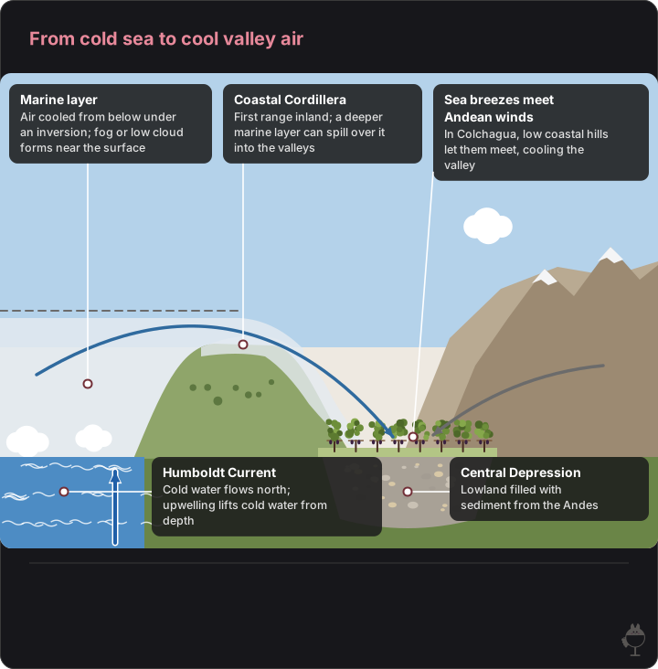
A cross-section from the Pacific (west, left) to the Andes (east, right). Heights, distances, layer thickness and the paths of the arrows are not to scale; shapes and colours are illustrative. The marine layer applies to west coasts in general; the meeting of the winds is that of Colchagua.
Read the figure as text
- Marine layer — Air cooled from below under an inversion; fog or low cloud forms near the surface
- Coastal Cordillera — First range inland; a deeper marine layer can spill over it into the valleys
- Sea breezes meet Andean winds — In Colchagua, low coastal hills let them meet, cooling the valley
- Humboldt Current — Cold water flows north; upwelling lifts cold water from depth
- Central Depression — Lowland filled with sediment from the Andes
Rocks, sediments and climate between the ranges
The Coastal Cordillera of central Chile contains a large granitic body, the Coastal Batholith. Zircon dating of its rocks in south-central Chile gives ages of about 300–320 million years, in the late Carboniferous (Pennsylvanian). The topsoils of named valleys are not described here.
The Central Depression is mostly bounded by faults. It is a natural receptacle for material from the Andes and has been filled with alluvial, fluvioglacial or moraine sediments, depending on the region.
In the Köppen climatic regionalisation of continental Chile by Sarricolea and colleagues, the centre of the country is dominated by Mediterranean climates. Between 33°S and 39°S the Csb type runs from the coastline up to about 1,200 m above sea level; above that it gives way to a cooler variant, Csc.
Elevation and slope aspect: apart from that 1,200 m climatic boundary, this article gives no vineyard elevations or aspects for Casablanca, Leyda or Apalta.
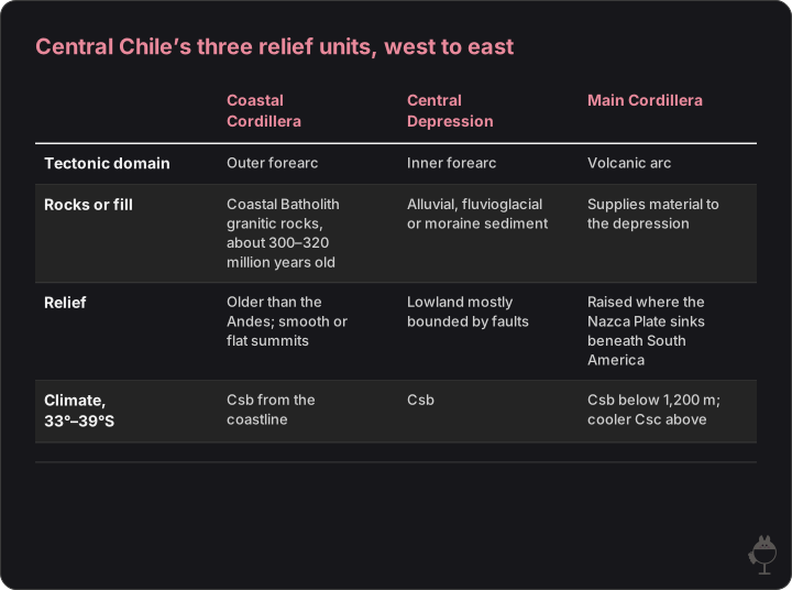
Ages come from zircon dating in south-central Chile; climate types from the Köppen regionalisation of continental Chile.
Read the figure as text
| Coastal Cordillera | Central Depression | Main Cordillera | |
|---|---|---|---|
| Tectonic domain | Outer forearc | Inner forearc | Volcanic arc |
| Rocks or fill | Coastal Batholith granitic rocks, about 300–320 million years old | Alluvial, fluvioglacial or moraine sediment | Supplies material to the depression |
| Relief | Older than the Andes; smooth or flat summits | Lowland mostly bounded by faults | Raised where the Nazca Plate sinks beneath South America |
| Climate, 33°–39°S | Csb from the coastline | Csb | Csb below 1,200 m; cooler Csc above |
Inland valleys: where sea breezes meet Andean winds
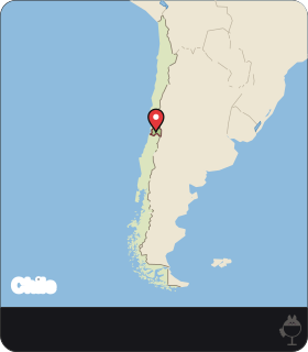
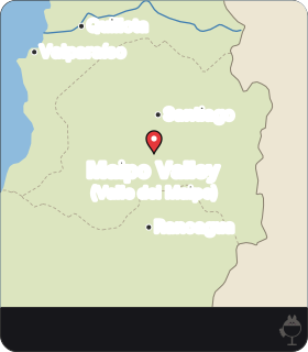
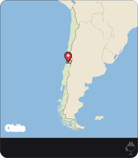
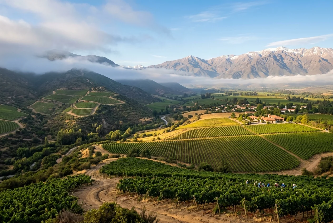
The Maipo Valley has a mild Mediterranean climate, with hot, dry summers and cold, wet winters. Its eastern vineyards sit in the foothills of the Andes, its western vineyards reach the sandy soils of the coastal range, and its main variety is Cabernet Sauvignon.
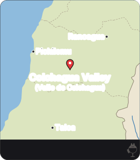
Further south, the Colchagua Valley lies in the southern half of the Rapel Valley. The low elevation of the coastal hills there lets Pacific breezes interact with winds from the Andes, cooling the valley and extending the ripening period.
What a longer season can and cannot do for green notes is the subject of section 7.
Carmenère: a Bordeaux variety found again in Chile
Carmenère came to Chile from Bordeaux in the mid-19th century, together with other Bordeaux varieties, and was long grown there as Merlot. In Bordeaux itself the variety became rare after phylloxera.
In 1994 the French ampelographer Jean-Michel Boursiquot identified vines growing in Chile as 'Merlot' as Carmenère. Chile thus became the main home of a variety that, for a long time, almost no one had knowingly made into wine.

 AI
·
Autumn leaves and dark grapes
Image: Maison Apéro (generated image) · Maison Apéro original
Green pepper notes: what light on the clusters really changes
Bell pepper, asparagus and pea characters in wine are attributed to methoxypyrazines, a group of aroma compounds. Black pepper is different: it comes from the sesquiterpene rotundone.
One of these compounds is 3-isobutyl-2-methoxypyrazine (IBMP). In a study of Cabernet Franc in New York State, Ryona and colleagues found that IBMP accumulates in the berry from fruit set until about 0 to 14 days before véraison and declines afterwards. Exposing the clusters to light lowered accumulation before véraison by 21 to 44 per cent compared with shaded clusters, but did not speed up the decline after véraison. Levels two weeks before véraison were closely correlated with levels at harvest.
The practical reading is that light around the bunches works early, before véraison, rather than as a late 'burn-off' near harvest. The study was on Cabernet Franc, not Carmenère.
In the glass, keep the two peppers apart: bell pepper, asparagus or pea point to methoxypyrazines, while black pepper points to rotundone.
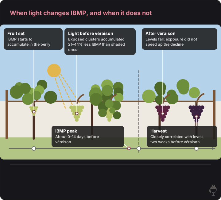
One row of vines through the season, left to right; the dashed line marks véraison. Before véraison, the left cluster is in sunlight and the right one is shaded by leaves. Based on Ryona and colleagues’ study of Cabernet Franc in New York State. Spacing in time is not to scale; shapes and colours are illustrative.
- In the glass, bell pepper, asparagus or pea notes point to methoxypyrazines; black pepper points to rotundone.
Read the figure as text
- Fruit set — IBMP starts to accumulate in the berry
- Light before véraison — Exposed clusters accumulated 21–44% less IBMP than shaded ones
- After véraison — Levels fall; exposure did not speed up the decline
- IBMP peak — About 0–14 days before véraison
- Harvest — Closely correlated with levels two weeks before véraison
Practice question 1: how coastal air is cooled
Question
Explain, step by step, how the Humboldt Current can lower air temperatures on the Pacific side of central Chile, and what decides whether the cool air reaches inland valleys.
Model answer
The Humboldt Current carries cold sub-Antarctic water north along the coast, and upwelling brings cold water from depth to the surface. Air over the cold water is cooled from below and an inversion forms; beneath it lies a cool, moist marine layer, in which low cloud or fog can form. When the marine layer deepens, cool marine air can spill over the coastal mountains into inland valleys. In central Chile the first barrier is the Coastal Cordillera; where its hills are low, as in Colchagua, Pacific breezes reach the valley and meet winds from the Andes.
Self-check points
– Names the cold current and upwelling as the source of cold surface water.
– Explains the inversion and the marine layer, with fog or low cloud.
– Links how far the cool air reaches inland to the depth of the marine layer and the height of the coastal hills.
Practice question 2: light, véraison and green notes
Question
A grower wants fewer green pepper notes in a red variety and plans to remove leaves around the bunches two weeks before harvest. Using the Cabernet Franc study by Ryona and colleagues, explain whether this timing is likely to work.
Model answer
In that study, IBMP accumulated from fruit set until about 0 to 14 days before véraison. Exposing clusters to light reduced accumulation before véraison by 21 to 44 per cent but did not speed up the decline after véraison, and levels two weeks before véraison were closely correlated with levels at harvest. Leaf removal two weeks before harvest comes after véraison, when exposure no longer changed the decline, so it is unlikely to lower IBMP. Exposing the bunches before véraison fits the findings better. Because the study was on Cabernet Franc, the answer should note that Carmenère needs its own data.
Self-check points
– States when IBMP accumulates and when it declines.
– Uses the finding that light acts before véraison, not after.
– Notes the limits: one variety, studied only in New York State.
Ocean and relief
- Cold current and upwelling
- Marine layer, fog and the Coastal Cordillera
Valley and vine
- Sea breezes meet Andean winds where the coastal hills are low
- Light on clusters before véraison limits IBMP
In the glass
- Bell pepper, asparagus or pea: methoxypyrazines
- Black pepper: rotundone, not pyrazines
Frequently asked questions
Why is the Humboldt Current called a cold current?
It carries sub-Antarctic water north along the coasts of Chile and Peru. Like other currents on the west coasts of continents it flows towards the equator, bringing cool water from polar regions, and upwelling brings cold water from depth to the surface.
When was Carmenère identified in Chile?
In 1994, when the French ampelographer Jean-Michel Boursiquot identified vines grown in Chile as Merlot as Carmenère. The variety had come to Chile from Bordeaux in the mid-19th century.
Does sunlight burn off green pepper notes just before harvest?
Not according to a study of Cabernet Franc by Ryona and colleagues. Light on the clusters reduced IBMP accumulation before véraison by 21 to 44 per cent but did not speed up its decline after véraison, so light matters early in the season.
Sources
- Global Environment Facility: Connecting the Current – ecosystem-based management of the Humboldt Current large marine ecosystem
- NOAA JetStream: Ocean circulations
- Encyclopedia.com: Peru Current
- Encyclopaedia Britannica: Lima
- NOAA JetStream: The marine layer
- Santibáñez et al. (2019), Crustal faults in the Chilean Andes: geological constraints and seismic potential, Andean Geology 46 (1)
- U.S. Geological Survey, This Dynamic Earth: Understanding plate motions
- Encyclopaedia Britannica: Chile – the intermediate depression
- U-Pb geochronology and Hf-O isotopes of zircons from the Pennsylvanian Coastal Batholith, south-central Chile (ResearchGate record)
- Sarricolea, Herrera-Ossandon and Meseguer-Ruiz (2017), Climatic regionalisation of continental Chile, Journal of Maps
- Wines of Chile: Winegrowing regions
- Wine Enthusiast: Rediscovering Chilean Carmenère
- Robinson et al. (2014), Origins of grape and wine aroma. Part 1. Chemical components and viticultural impacts, Am. J. Enol. Vitic. 65 (1)
- Ryona et al. (2008), Effects of cluster light exposure on 3-isobutyl-2-methoxypyrazine accumulation and degradation patterns in red wine grapes (Vitis vinifera L. cv. Cabernet Franc), J. Agric. Food Chem. 56 (22), PubMed abstract


