

How the Vosges keep the rain off the vineyards
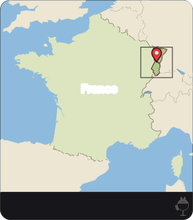
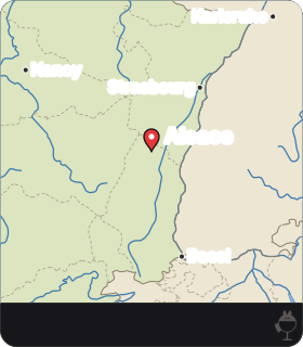
The Alsace vineyards follow the eastern foothills of the Vosges, between the mountains and the Rhine plain. The dominant winds blow from the west and bring oceanic air. These westerlies discharge their rain on the western slopes of the Vosges and then descend, dried, over the vineyards: the mountains shelter Alsace from oceanic influences.
Meteorologists call the result a rain shadow: an area of reduced precipitation on the lee side of a mountain barrier, where the descending air warms and clouds dissipate. In Alsace the barrier is the Vosges, and the lee side is the east, where the vines grow.
The climate of the vineyard is continental, sunny, warm and dry, with one of the lowest rainfalls in France: 500 to 600 mm of water a year (CIVA). The block diagram below follows the air from the western slopes to the vineyards and shows the rift valley beneath them.
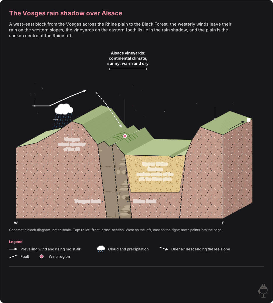
Schematic block diagram, not to scale: the top shows the relief and the front face a cross-section, coloured by soil and rock type.
Read the figure as text
- The dominant westerly winds discharge their rain on the western slopes of the Vosges and descend dried over the vineyards; the Vosges shelter Alsace from oceanic influences.
- The Alsace vineyards have a sunny, warm and dry continental climate, with one of the lowest rainfalls in France.
- A rain shadow is an area of reduced precipitation on the lee side of a mountain barrier, where the descending air warms and clouds dissipate.
- The Rhine graben is a rift: its centre has sunk while its shoulders, the Vosges to the west and the Black Forest to the east, stand raised relative to it. Faults border the Upper Rhine Graben and the Alsace plain.
- The vineyards grow on the sub-Vosges hills, a field of fractures between the Vosges fault to the west and the Rhine fault to the east, between the Vosges and the Rhine plain.
How dry is dry? Colmar, Strasbourg and Paris compared
Climate normals give a firmer measure than adjectives. Météo-France publishes 30-year averages for its stations. For 1991–2020, the normal annual precipitation is 595.0 mm at Colmar-Meyenheim, 635.7 mm at Strasbourg-Entzheim and 634.3 mm at Paris-Montsouris.
Colmar-Meyenheim is the driest of the three and falls within the 500 to 600 mm range that CIVA gives for the vineyard. Yet its gap with Paris is 39.3 mm, about 6 per cent of the Paris total. The claim, sometimes repeated, that Alsace receives less than half the rain of Paris does not match these normals. Strasbourg-Entzheim even receives slightly more than Paris-Montsouris.
A normal describes the one place where the rain gauge stands, not every slope around it. These values are best read as an order of magnitude for the area.
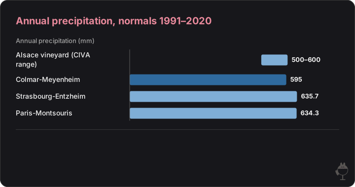
Météo-France normals for 1991–2020 at three stations, with the range that the Alsace wine interprofession (CIVA) gives for the vineyard. Colmar-Meyenheim is the driest station, by 39.3 mm compared with Paris-Montsouris, not by half.
Read the figure as text
Annual precipitation (mm)
- Alsace vineyard (CIVA range): 500–600 mm
- Colmar-Meyenheim: 595 mm
- Strasbourg-Entzheim: 635.7 mm
- Paris-Montsouris: 634.3 mm
When the difference appears: the cold half of the year
The monthly normals show when Colmar is drier. From November to April, Colmar-Meyenheim receives less rain than Paris-Montsouris in every month; from May to October, it receives more in every month. Added up, Colmar collects 227.3 mm from November to April against 296.7 mm in Paris, and 367.7 mm from May to October against 337.6 mm.
February is the driest month at both stations (30.6 mm at Colmar, 41.8 mm at Paris) and May the wettest (69.8 mm and 69.0 mm). Colmar's lower annual total therefore comes from the cold half of the year; its wetter warm half offsets part of that deficit.
This matters when reading claims about ripening. Rainfall alone does not show that autumn is drier in Colmar than in Paris: the September and October normals are 51.3 mm and 56.8 mm at Colmar, against 44.7 mm and 55.2 mm at Paris. The amount of rain says nothing by itself about sunshine, humidity or disease pressure, which need their own measurements.
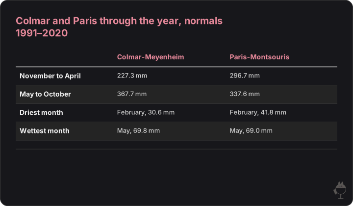
Sums of the Météo-France monthly normals for 1991–2020. Colmar receives less rain than Paris in every month from November to April, and more in every month from May to October.
Read the figure as text
| Colmar-Meyenheim | Paris-Montsouris | |
|---|---|---|
| November to April | 227.3 mm | 296.7 mm |
| May to October | 367.7 mm | 337.6 mm |
| Driest month | February, 30.6 mm | February, 41.8 mm |
| Wettest month | May, 69.8 mm | May, 69.0 mm |
The rift beneath the vineyard
The relief that creates the rain shadow is also the edge of a rift. In the Upper Rhine Graben the centre has sunk to form the Rhine plain, while its shoulders, the Vosges to the west and the Black Forest to the east, stand raised relative to it (Planet-Terre, ENS de Lyon). The vineyards grow on the sub-Vosges hills, a field of fractures between the Vosges fault to the west and the Rhine fault to the east.
This shaped the soils. About 150 million years ago the sea covered what is now the Rhine rift valley, and sedimentary rocks such as sandstone, limestone and marl settled on the granite basement. On the Alsace side three units stand out: the Vosges mountains (granite and sandstone, sometimes shale), the sub-Vosges hills with their great diversity of soils, and the Rhine alluvial plain (marl and alluvium). Four fracture fields, Saverne, Ribeauvillé, Rouffach-Guebwiller and Thann, break up the wine-growing area further.
The result is a mosaic. Most wine villages stand on four or five different formations, often in very small adjoining parcels, across a vineyard of about 15,500 hectares. Much of the diversity of Alsace wines comes from this patchwork of soils (CIVA).

 AI
·
Cellar and rock samples
Image: Maison Apéro (generated image) · Maison Apéro original
Two grands crus, two rocks: Brand and Rangen
Rock, aspect and altitude combine on a single site. The Brand at Turckheim rests on granite, a rock of quartz, feldspar and mica that gives a sandy, coarse soil. It faces south-south-east and climbs to 380 metres. This subsoil warms the root zone, which favours good ripening and the breakdown of malic acid (CIVA).
The Rangen, at Thann and Vieux-Thann, is a steep, south-facing slope on volcanic and sedimentary rocks. The two sites illustrate the mosaic described above: within the same rain-shadow climate, granite at Turckheim, volcanic and sedimentary rocks at Thann.
Exercise 1: the rain shadow in numbers
Question
Explain how the Vosges create a rain shadow over the Alsace vineyards, then use the Météo-France normals for 1991–2020 to assess the claim that Alsace receives less than half the annual rainfall of Paris.
Model answer
The dominant westerly winds bring oceanic air towards the Vosges. They discharge their rain on the western slopes and descend, dried and warmed, over the vineyards on the eastern foothills, an area of reduced precipitation on the lee side of the barrier. The vineyard's rainfall is 500 to 600 mm a year (CIVA). The normals give 595.0 mm at Colmar-Meyenheim against 634.3 mm at Paris-Montsouris: a gap of 39.3 mm, or about 6 per cent. The claim is therefore wrong: Colmar is drier than Paris, but not by half. The monthly normals show that the difference arises from November to April.
Mark scheme (10 marks)
- Westerly winds, rain on the western slopes, dried air descending to the east (3 marks)
- Correct use of the 1991–2020 normals for Colmar-Meyenheim and Paris-Montsouris (4 marks)
- A justified conclusion that the claim is wrong, noting that the difference lies in the cold half of the year (3 marks)
Exercise 2: reading the soil mosaic
Question
Describe how the Upper Rhine Graben produced the soil mosaic of the Alsace vineyard, and contrast the rocks of the Brand and Rangen grands crus.
Model answer
The Rhine plain is the sunken centre of a rift whose raised shoulders are the Vosges and the Black Forest. The vineyards lie on the sub-Vosges hills, a field of fractures between the Vosges fault and the Rhine fault, where sedimentary rocks (sandstone, limestone, marl) laid down on the granite basement are cut up by faults. Four fracture fields divide the area further, so that most villages stand on four or five formations. The Brand at Turckheim is granite of quartz, feldspar and mica giving a sandy, coarse soil, facing south-south-east and rising to 380 metres; the Rangen at Thann and Vieux-Thann is a steep south-facing slope on volcanic and sedimentary rocks.
Mark scheme (10 marks)
- The rift: sunken plain, raised Vosges and Black Forest, the two bounding faults (4 marks)
- The mosaic: sedimentary cover over granite, fracture fields, four or five formations per village (3 marks)
- An accurate contrast of Brand and Rangen (rock, aspect) (3 marks)
Wind and relief
- Dominant westerly winds bring oceanic air
- The Vosges stand in their path
Rain shadow
- Rain falls on the western slopes
- Dried, warmed air descends over the eastern foothills
In the vineyard
- Colmar-Meyenheim: 595.0 mm a year (normals 1991–2020)
- The soils of the fracture field change from plot to plot
Frequently asked questions
Why is Alsace so dry?
Because the Vosges stand in the path of the dominant westerly winds. The winds discharge their rain on the western slopes and descend, dried, over the vineyards on the eastern foothills. The vineyard's rainfall is 500 to 600 mm a year (CIVA), one of the lowest in France.
Does Alsace really get half the rain of Paris?
No. Météo-France normals for 1991–2020 give 595.0 mm a year at Colmar-Meyenheim and 634.3 mm at Paris-Montsouris. Colmar is drier by about 6 per cent, and the difference arises from November to April.
What soils are found in the Alsace vineyard?
A mosaic. The vineyard lies on a field of fractures at the edge of the Upper Rhine Graben, where granite, shale, sandstone, limestone, clay and marl occur side by side. Most villages stand on four or five formations; the Brand grand cru is on granite, the Rangen on volcanic and sedimentary rocks.
See also: What is a rain shadow? (Mountain Ranges and Their Shadows: Rain Shadows Compared from the Cascades to the Alps)
Sources
- Vins d'Alsace (CIVA) — Terroir and viticulture in Alsace: the genius of the terroir
- Vins d'Alsace (CIVA) — Geology of Alsace terroirs
- Vins d'Alsace (CIVA) — Grand Cru Brand
- Vins d'Alsace (CIVA) — Grand Cru Rangen
- Planet-Terre (ENS de Lyon) — Fracture fields and wine in Alsace
- NOAA National Weather Service — Glossary: rain shadow
- Météo-France — Climate sheet, 1991–2020 statistics and records: Colmar-Meyenheim
- Infoclimat — Climate normals and records 1991–2020 at Colmar-Meyenheim
- Météo-France — Climate sheet, 1991–2020 statistics and records: Strasbourg-Entzheim
- Météo-France — Climate sheet, 1991–2020 statistics and records: Paris-Montsouris
- Natural Hazards and Earth System Sciences (2024): Update on the seismogenic potential of the Upper Rhine Graben southern region
- NOAA National Weather Service glossary: orographic


