

What a climat is
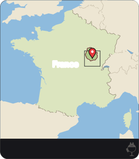
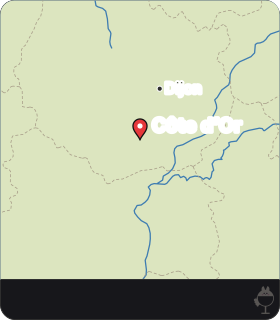
The climats are precisely delimited vineyard parcels on the slopes of the Côte de Nuits and the Côte de Beaune. The slopes run for about 50 km, from just south of Dijon to the Maranges.
What sets one climat apart from its neighbour is a combination of natural conditions, chiefly geology and exposure, and the vines grown there. People have shaped each parcel through cultivation, and over time each came to be recognised by the wine it produces. The name on the label therefore points to a place, not to a brand or a blend of sites.
The Climats, terroirs of Burgundy were inscribed on the UNESCO World Heritage List in 2015.
Dijon, Beaune and the villages
The World Heritage property has two parts. The first covers the vineyards together with the villages and the town of Beaune, linked to the commercial side of the system. The second is the historic centre of Dijon, presented as the source of the political and regulatory impetus that gave rise to the climats.
This way of growing grapes and making wine has developed since the Middle Ages. The listing therefore does not stop at the parcels: it also takes in the towns that traded the wines and set their rules.
Soils that change from parcel to parcel
Two families of rock recur in descriptions of the slope: limestone, a hard rock made mostly of calcium carbonate, and marl, a softer mixture of clay and carbonate.
As a general principle of soil physics, a clay-rich marl holds more water than a thin soil over fissured hard limestone, where water drains away quickly and roots follow the cracks in the rock. How much of each lies under a given parcel, and how deep the soil is, has to be read from a geological map or a soil pit; it cannot be inferred from a climat's name or reputation.

 AI
·
Soil pit and harvest crate
Image: Maison Apéro (generated image) · Maison Apéro original
The Jurassic stages and their ages
The limestones and marls of the Côte are Jurassic sedimentary rocks, and they are named by stage. The stages include the Bajocian and Bathonian (Middle Jurassic) and, in parts of the Côte de Beaune, the Callovian and Oxfordian. Which stage crops out under which climat is a matter for the geological map. Without a map to hand, treat these names as orientation rather than as a description of any one parcel.
On the International Chronostratigraphic Chart, the Bajocian runs from 170.9 to 168.2 million years ago, the Bathonian from 168.2 to 165.3, the Callovian from 165.3 to 161.5 and the Oxfordian from 161.5 to 154.8. The chart gives each of these boundaries with a margin of uncertainty, but the order of the stages does not change. The Oxfordian is therefore several million years younger than the Bathonian.
That order matters when reading a cross-section. In an undisturbed sequence of sedimentary beds, younger layers lie above older ones, so an Oxfordian marl cannot sit beneath a Bathonian limestone unless faulting or folding has moved the beds.
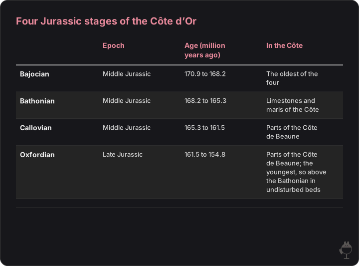
The stages named in this article, from oldest to youngest, with their ages on the International Chronostratigraphic Chart. In undisturbed beds the younger stage lies above the older one; which stage lies under a given climat is a matter for the geological map.
Read the figure as text
| Epoch | Age (million years ago) | In the Côte | |
|---|---|---|---|
| Bajocian | Middle Jurassic | 170.9 to 168.2 | The oldest of the four |
| Bathonian | Middle Jurassic | 168.2 to 165.3 | Limestones and marls of the Côte |
| Callovian | Middle Jurassic | 165.3 to 161.5 | Parts of the Côte de Beaune |
| Oxfordian | Late Jurassic | 161.5 to 154.8 | Parts of the Côte de Beaune; the youngest, so above the Bathonian in undisturbed beds |
Altitude, slope and aspect
On the Côte de Nuits (Burgundy wine board, BIVB), vineyards lie at altitudes of 230 to 300 m, on slopes that are often steep, up to about 25%, facing mainly east to south-east. Its best-known appellations lie at mid-slope, between the plateau of the Hautes-Côtes above and the flatter land below.
Two general principles help explain why mid-slope positions are prized, though neither is a measurement for any particular climat. Water and fine material move downslope, so soils on the middle of a slope are often thinner and better drained than those at its foot. On clear, still nights, cold air also drains downhill and collects on low, flat ground, where the risk of spring frost is higher.
An east to south-east aspect means the vines receive the morning sun. Exact orientations, gradients and altitudes differ from one climat to the next and should be read from the delimitation maps rather than assumed from the figures above.
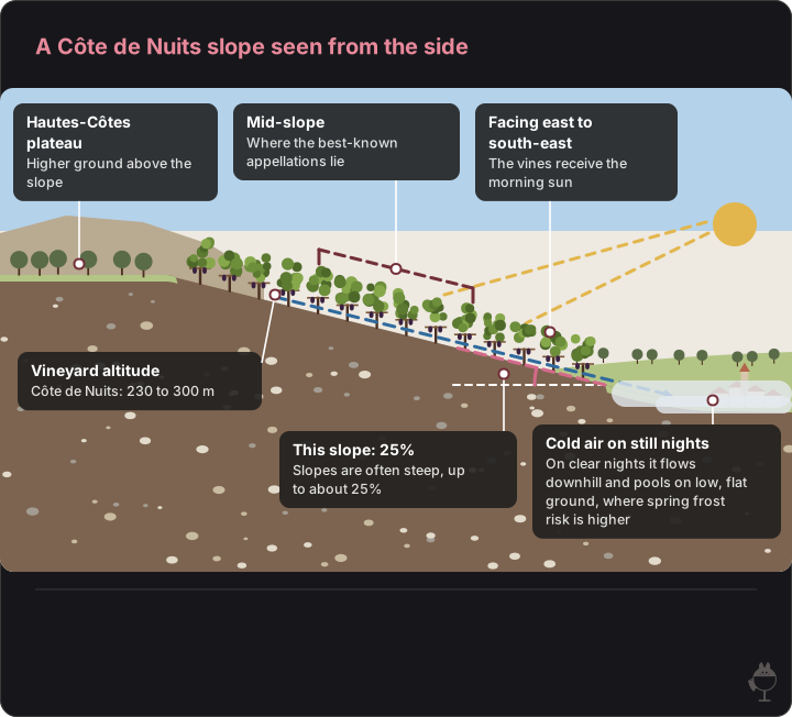
The drawn hillside rises at 25%, the steepest gradient on the Côte de Nuits (BIVB), with east on the right. It is not a particular climat: soils, heights and the cold-air path are not drawn to scale, and the arrow shows a general principle, not a measurement. Shapes and colours are illustrative.
Read the figure as text
- Hautes-Côtes plateau — Higher ground above the slope
- Mid-slope — Where the best-known appellations lie
- Facing east to south-east — The vines receive the morning sun
- Vineyard altitude — Côte de Nuits: 230 to 300 m
- This slope: 25% — Slopes are often steep, up to about 25%
- Cold air on still nights — On clear nights it flows downhill and pools on low, flat ground, where spring frost risk is higher
Climate and an earlier harvest
The longest homogeneous series of grape harvest dates comes from Beaune. In 2019, Labbé and colleagues rebuilt from archival records a homogeneous series of Beaune harvest dates covering 1354 to 2018.
The series shows a clear break. Since 1988, harvests in Beaune have begun on average 13 days earlier than over the preceding centuries of the record, a shift the authors link to warming. As a general rule, ripening that ends in the hotter weeks of late summer tends to give grapes with more sugar and less acidity; this is a general tendency, not a measurement for any one climat.
Spring frost and summer hail are often named as risks in Burgundy.
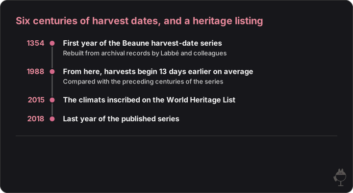
Four dates: the span of the Beaune harvest-date series, the start of its run of earlier harvests and the UNESCO inscription of the climats.
Read the figure as text
- 1354 — First year of the Beaune harvest-date series. Rebuilt from archival records by Labbé and colleagues
- 1988 — From here, harvests begin 13 days earlier on average. Compared with the preceding centuries of the series
- 2015 — The climats inscribed on the World Heritage List
- 2018 — Last year of the published series
Two grape varieties, one site at a time
In the regional AOC Bourgogne, Pinot Noir is the main variety for red wine and Chardonnay for white. Because reds and whites each rest on one main variety, differences in blending interfere less when the wines of neighbouring climats are compared.
The most famous climats are also appellations in their own right. A grand cru such as Chapelle-Chambertin has its own cahier des charges as an appellation d'origine contrôlée, which sets out its delimited area and its rules of production.
The idea of transparency often attached to Burgundy follows from this: when variety and method stay broadly the same, the differences that remain point back to the place. It is an interpretation, not a law; vintage and the grower's choices matter too.
Exercise 1: why the middle of the slope?
Question
Using the altitude, gradient and aspect given for the Côte de Nuits, explain why vineyards at mid-slope are often preferred to those at the foot of the slope.
Model answer
The vineyards of the Côte de Nuits lie at 230 to 300 m (BIVB), on slopes of up to about 25%, facing mainly east to south-east. Because water and fine material move downhill, soils at mid-slope tend to be thinner and better drained. On clear, still nights cold air flows down to low, flat ground, so mid-slope parcels are less exposed to spring frost. An eastern aspect brings the morning sun. These are general principles; the conditions of a particular climat have to be checked on a map.
Mark scheme (10 marks)
- Altitude, gradient and aspect quoted correctly (3 marks)
- Drainage and soil depth explained as a downslope process (3 marks)
- Cold-air drainage and frost risk explained (3 marks)
- States that general principles do not replace data for the parcel (1 mark)
Exercise 2: reading the order of the beds
Question
A cross-section shows Oxfordian marl lying beneath Bathonian limestone, with no fault or fold marked. Using the ages of the stages, explain why the section must be wrong.
Model answer
On the International Chronostratigraphic Chart the Bathonian spans 168.2 to 165.3 million years ago and the Oxfordian 161.5 to 154.8, so the Oxfordian rocks are younger. In an undisturbed sedimentary sequence, younger beds lie on top of older ones. Oxfordian marl could appear below Bathonian limestone only if faulting, folding or overturning had displaced the beds, and the section would then have to show it. Without that, the order has been drawn upside down.
Mark scheme (10 marks)
- Stage ages quoted from the chart (4 marks)
- Principle that younger beds lie above older ones (4 marks)
- Names the exception, faulting or folding (2 marks)
Site
- Jurassic limestones and marls of variable composition
- Côte de Nuits slopes at 230–300 m facing east to south-east
Vine
- Drainage, soil depth and cold-air flow differ from parcel to parcel
Wine
- Each climat recognised over time by the wine it produces
Frequently asked questions
What is a climat in Burgundy?
A climat is a precisely delimited, named vineyard parcel on the slopes of the Côte de Nuits or the Côte de Beaune. Climats differ in geology and exposure, are shaped by cultivation and are recognised over time by the wine they produce. The Climats, terroirs of Burgundy were inscribed on the World Heritage List in 2015.
Why are many famous Côte de Nuits vineyards at mid-slope?
The Côte de Nuits has vineyard altitudes of 230 to 300 m, slopes of up to about 25% and a mainly east to south-east aspect, with its best-known appellations at mid-slope (BIVB). As general principles, mid-slope soils tend to drain better than those at the foot of the slope, and cold air on still nights collects on low ground, where frost risk rises.
Is the harvest in Burgundy getting earlier?
In Beaune, yes. A homogeneous series of harvest dates covering 1354 to 2018 (Labbé et al., 2019) shows that since 1988 harvests have begun on average 13 days earlier than over the preceding centuries of the record.
Sources
- UNESCO World Heritage Centre — The Climats, terroirs of Burgundy
- BIVB (Burgundy Wine Board) — Côte de Nuits and Hautes Côtes
- International Commission on Stratigraphy — International Chronostratigraphic Chart v2023/09
- Labbé et al. (2019), Climate of the Past 15 — The longest homogeneous series of grape harvest dates, Beaune 1354–2018
- INAO — Specification of the AOC Bourgogne
- Specification of the AOC Chapelle-Chambertin (BIVB)


